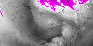
It had rained the last couple of days after a prolonged drought in April. The warm frontal system had brought 45 mm of much needed water. This boom or bust delivery of moisture is to be expected with climate change especially for eastern Ontario. The west coast of North America will bake under the heat of the persistent upper ridge. Eastern North America will be dominated by the downstream upper trough of low pressure. At least Singleton Lake will be cloudier with the weather systems that proper in the upper trough fueled by moisture flows from the Gulf of Mexico. We are blessed by the peculiarities of geography and meteorology at least until temperatures pass the tipping point.
I have presented this information since the mid 1980's when the then Director of the Atmospheric Environment Service told me that my climate change presentation using the early version of Power Point , scared him more than the one of severe convection. I gave countless presentations until I was told to stop. Oh my. Being retired, I continue to Blog on this science and any magazines that will publish it.
The cold front had passed through Singleton a few hours before this view of the afternoon sky. The hangback cloud and convection wrapped around the upper low that was still to the southwest of Lake Ontario. The clearing was on the western horizon but the lines of heavy convection from the northwest were still intense along the edge of the hangback deformation zone. The hangback would produce a few centimetres of accumulating snow overnight. The snow was quick to melt the following morning under clear and sunny skies.For this and much more art, click on Pixels. Thank you.


No comments:
Post a Comment