Monday, June 29, 2020

#2351 "Singleton April Snowsquall"

The cold and unstable air mass was producing very vigourous snow flurries. This particular towering cumulus was tilted over with the northwesterly winds. The banded structure of the backlit cumulus tower caught my eye along with the shaft of heavy snow reaching the ground. The snow even accumulated at least 2 centimetres. The ice was still hanging in the western basin of Singleton Lake.
For this and much more art, click on Pixels. Thank you.

Saturday, June 27, 2020

#2350 "Singleton Altostratus Sunset"

The hang back cloud in the wake of a spring storm stretched across the western horizon. The cyclonic confluent asymptote of the deformation zone has created the knife sharp edge separating the overhead overcast from the clear skies to the west. The colours in the sunset skies are always fascinating. The ice was just grey slush in the western basin of Singleton Lake.

I used a lot of oils on this small panel. It was fun.

For this and much more art, click on Pixels. Thank you.

Thursday, June 25, 2020

#2349 "After the March Squall"

The thunderstorm squall line had passed through. The sun was peeking between the cloud layers on the western horizon. There were some strong winds at Singleton but no real damage. Early season, low topped supercellular thunderstorms can bring some strong weather. I have witnessed freezing rain in the morning followed by a tornado in the afternoon. That is what keep the weather exciting. The west basin of Singleton Lake was still dominated by ice.

I used the minimum number of bold and rough strokes to record the moment of turbulent stratocumulus that followed the squall line of thunderstorms.

For this and much more art, click on Pixels. Thank you.


Monday, June 22, 2020

#2348 "Singleton March Squall Line"

The tops of the low topped supercell thunderstorms were visible just beyond the streets of turbulent stratocumulus. Horizontal tubes of rotation were certainly rolling along with the strong southerly flow. Vortices were being lifted and stretched and revealed by the swirls of clouds. This was the last day for the punky ice in the west basin of Singleton Lake.

Supercell thunderstorms are formed when the convective updraft lifts a horizontal roll into the vertical. One side of the roll spins cyclonically and the other side turns anticyclonically. Try it with a slinky coil to convince yourself that this is true. The thunderstorm splits into two updrafts. Typically the cyclonic updraft on the right flank of the original updraft dominates and turns to the right, intensifying as it does so. I relied on both satellite and radar remote sensing to witness the splitting of the original thunderstorm into two. Supercells are responsible for most severe events and they are the only type of convective storm that does this cell splitting process. People may want to see a tornado before they die, but not just before they die. Remote sensing was my friend.

The clouds always have an interesting tale to tell. We just need to slow down and enjoy the show.

For this and much more art, click on Pixels. Thank you.

Saturday, June 20, 2020

#2347 "Pink Singleton Spring Sunrise"

It was a beautiful spring sunrise looking eastward from beside the old shagbark hickory at Singleton. The deformation zones evident in the bands of thin cirrostratus were pointed northward in the morning sky. There were multiple layers of moisture in that warm conveyor belt and each intersected with the deformation zone skin to create it own rosy arch.

The cold conveyor belt helped to explain the widespread frost and the chilly temperatures the previous night. The gravity waves in the patchy stratocumulus revealed the easterly winds at the level of the clouds.

The weather story was for heavy rain later in the day. The sky confirmed that forecast. The conveyor belt conceptual model is perhaps the most important construct in meteorology.

I always enjoy the tall white pines that line Long Reach Lane. They poked up into the sunrise light. The snow and ice had melted from the field. The deer herd were happily grazing the front yard. The deer barely even raise their head to look at me anymore. The flock of turkeys was with the deer as well. Everybody was safe in the Singleton Sanctuary.

For this and much more art, click on Pixels. Thank you.

Thursday, June 18, 2020

#2346 "March Warm Frontal Rain"

It had rained all day. I love the rainy weather. Brisk southerly winds confirmed that the warm front was to the north of Singleton Lake. Eastern Ontario will be in the favoured location of the long wave atmospheric trough with climate change. Low pressure in the atmospheric is typically associated with clouds and precipitation and those are very good things on a hotter globe.

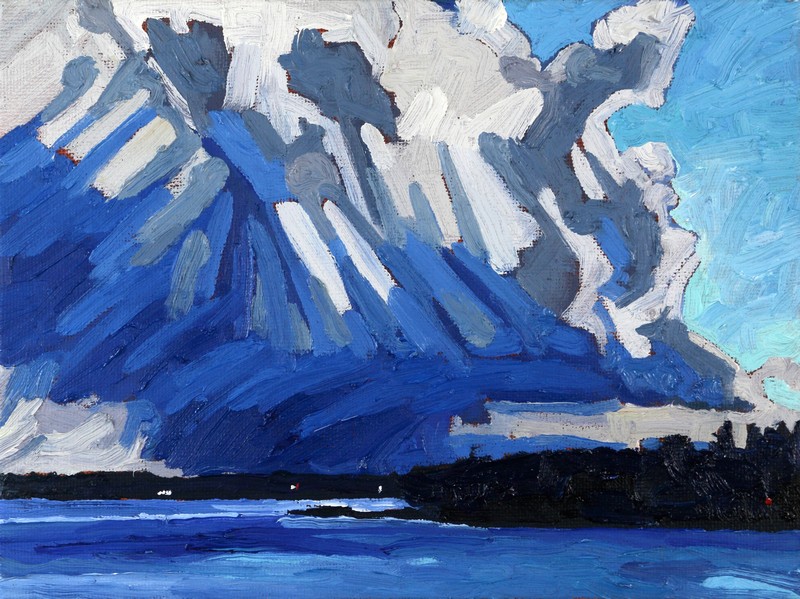
 The temperatures had spiked into the mid teens Celsius. The ice of the western basin was covered in water providing a clear reflection of the dark forest on the far shore. The ice was melting as well.

A line of instability was crossing the warm front. Severe thunderstorm watches were out for low topped supercells. This weather situation is typical for a spring warm sector with lots of wind shear and instability. There was a lot of energy in the sky and hopefully the oils.

The severe thunderstorms turned to the right and passed south of Singleton Lake. That's OK. People may want to see a tornado before they die... but not just before they die. That is why I am such a big fan of remote sensing.

For this and much more art, click on Pixels. Thank you.

Tuesday, June 16, 2020

#2345 "March Sunset Behind the Cold Front"

A cold front had swept across Singleton in the late afternoon. The wind was busy writing lines in the sky. It was enough just to appreciate the beauty of the weather. The sun was trying to break through the many layers of gravity lines in the sky.


Ice was still covering the west basin of the lake. The dark forest on that shore was reflecting in the calm waters of the lake but not on the rotten ice. That ice would soon be breaking up and gone.

For this and much more art, click on Pixels. Thank you.

Sunday, June 14, 2020

#2344 "Singleton Spring Altocumulus Sunrise"

The sunrise colours do not last long. Those shades of rose were fleeting at best. The pronounced gravity waves in the high based sheet of altocumulus told the weather story. The diagonal break in the cloud revealed that there were two different layers of cloud. The altocumulus overhead was based near 14 thousand feet above the surface. I do not have a ceilometer but checked the observation from Kingston Airport. This deck of cloud was likely on the cold side of the deformation zone. The higher deck of cirrus to the west was catching the sunrise rays.

This cirrus was the leading edge of the warm conveyor belt moisture with the approaching spring storm. Both cloud decks were drifting toward the south so this placed the col in the deformation zone further to the north. The approaching rain would be heavier to the north as well. The Kingston Observer even reported some virga which was consistent with the anticyclonic swirl with that portion of the warm conveyor belt.

The sunrise light was bright enough to illuminate the white cottages on the western shore of Singleton. Ice was still filling the west basin of the lake. The dark forest on that shore was reflected in the calm waters of the lake but not on the rotten ice. That ice would soon be break up and be gone. We thought we saw a loon scouting out the lake for sufficient open water to land and take-off again. Loons require a bit of a runway.

The work that trained weather observers do cannot be replaced by a machine although I like the old SA code much better. CYGK 261200Z 18009KT 15SM BKN140 BKN240 03/02 A2995 RMK AC7CI1 CI TR VIRGA SLP146

For this and much more art, click on Pixels. Thank you.


Friday, June 12, 2020

#2343 "Singleton Spring Eve Sunset"

A warm conveyor belt was charging out of the southwestern horizon. Langmuir cirrus shafts at the highest levels were shooting ahead of the thicker and more organized layers of cirrostratus further to the southwest. The streaks of cirrus were distorted with the wind shear between the different layers of the atmosphere. The ice crystals of the cloud were shaped in unison across the entire conveyor belt. The process was similar to that for mare’s tails and one could easily brand these patterns with that equestrian name. Sometimes the weather is indeed like a horse race placing your bets on how the weather will evolve and doing your best to get the forecast out before the reality occurs.

The ice that filled the west basin of Singleton Lake was a chameleon that took on different colours depending on the light and even the temperature. In the sunset light there was a crimson grey colour to the ice.

In 2020, the spring equinox (also called the March equinox or vernal equinox) occurs on Thursday, March 19, which is earlier than it's been in over a century! This event marks the astronomical first day of spring in the Northern Hemisphere. 2020 Thursday, March 19, at 11:50 P.M. EDT. As a result spring had actually arrived a couple of days earlier than my painting at 11:50 P.M. EDT on Thursday, March 19, 2020. I was just slow catching up.

The word equinox comes from the Latin words for "equal night"—aequus (equal) and nox (night). On the equinox, the length of day and night is nearly equal in all parts of the world. On the March equinox, the Sun crosses the celestial equator from south to north. It's called the "celestial equator" because it's an imaginary line in the sky above the Earth's equator. If you were standing on the equator, the Sun would pass directly overhead on its way north. Equinoxes are the only two times a year that the Sun rises due east and sets due west for all of us on Earth.


For this and much more art, click on Pixels. Thank you.


Sunday, June 7, 2020

#2342 "Spring Ice Sunset"

The colours in the sunset scene were what I was after. The stratocumulus had some earthy browns to it while the clear sky in the distant horizon was radiant white with purity of colour. The backlit clouds had haloes of rose and mauve. The calm waters of Singleton reflected this world upside down. Ice still dominated the western basin of the lake. The three permanent homes on the western shore of Singleton could not see this drama. Spring was around the meteorological corner.

The sketch is not perfect but I would certainly mess it up if I tried to fix the imperfections that I saw.

For this and much more art, click on Pixels. Thank you.

Thursday, June 4, 2020

#2341 "Singleton Altostratus Sunset"

I wanted to capture the dull glow of the late afternoon sun shining through the thick layers of altostratus. The warm conveyor belt from the next storm was approaching Singleton Lake. The sky was dark and foreboding and it was still very much like winter for March 18th. The typical progression of the weather is that this cloud would thicken up into nimbostratus which would produce the rain. In fact that was also the official forecast. "Altostratus coming at us" was the same prediction implied as with "cirrostratus coming at us".

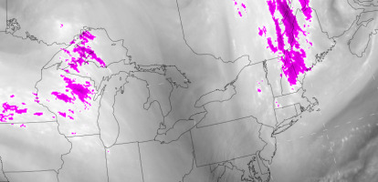
Water Vapour Image of the Warm Conveyor Belt
The arc of the confluent asymptote of the deformation zone was evident in each layer of the cloud. There were several layers of the moisture in the atmosphere west of Singleton Lake and each display the characteristic arc. The cloud elements were moving to the right indicating that the cyclonic portion of the system was headed towards us. One can confirm this by pointing the fingers of your right hand in the direction of the cloud movement. Your thumb must be pointing up.

The rain from this system actually passed by just south of Singleton. It was close but all we saw was the virga wafting down from the altostratus as I subtlety included in the weather observation I call a painting. The rocks were dry when I got up the following morning. Errors were a fact of life in the weather centre. A wise meteorologist would continue to analyse and diagnosis the atmospheric motions and quickly detect the change in the weather script. A revised forecast or amendment was not so much admitting a mistake but reflecting the complexity of the real atmosphere and making the weather forecast closer to the evolving truth.

A yes or no deterministic forecast may also be what most people want. Will it rain or not? The decision is made for them. However every forecast is a bit of a gamble. The weather evolves and the laws of probability determine the outcome based on the physics of the air flows. The weather really is that complicated in the huge dimensions of space and time.

For this and much more art, click on Pixels. Thank you.

#2845 "Female Snowy Owl"

#2845 "Female Snowy Owl" 18x14 oils on stretched canvas Started Saturday, February 17th, 2024 This female snowy owl had a whimsica...