Friday, September 30, 2022

#2690 "Hangcliff Point"

#2690 "Hangcliff Point"
8x10 canvas oils
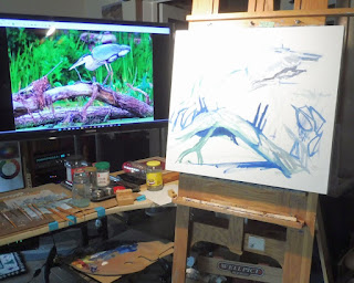
I have been to Hangcliff Point in Georgian Bay near Parry Sound. This view from the water would require a pontoon boat as a plein air painting platform. The water is much too deep for my field easel. As a result, this is a Singleton Studio painting with the music on loud. I was pretending to be on location. It was also far too hot to paint outside with the temperatures well into the thirties and the "feels-like" humidex values of forty Celsius plus. There were countless new all-time records for heat being set in North America. 

One of the interesting features of Hangcliff Point is the amazing tree growing from the crack in the point. There was minimal soil to support its growth. My friend observed that the tree "hasn’t grown much in 25 years". At least the tree is still alive. My friend used to take his kids fishing there and they usually caught something. 

This is the way that Hangcliff Point looked at sunrise on Saturday July 30th, 2022. The morning light can be golden. 

The body of water that gives the town its name was surveyed and named by Captain Henry Bayfield in the 19th century in honour of the Arctic explorer Sir William Edward Parry. In 1857, the modern townsite was established near the Ojibwa village of Wasauksing ("shining shore") at the mouth of the Seguin River. 

For this and much more art, click on Pixels.

Warmest regards and keep your paddle in the water,

Phil Chadwick


Monday, September 26, 2022

#2689 "Sunset August Fourth Anvils"

#2689 "Sunset August Fourth Anvils"
14x18 inches oils

The cumulonimbus was north of YTR.
Singleton is almost exactly equidistant
between YGK, WJM and WGH. 
The weather is always inspirational. The thunderstorm was far to the west and actually north of Trenton. According to radar, the central updraft of the convective cell measured 160 kilometres to the west - one hundred miles. 

What really caught my eye were the tendrils of clouds drifting down from the anvil and intercepting the sunset light. The fiery show of colour and shape lasted for several minutes and was etched into my mind. The virga process would have been similar to that which produces mammatus but in this case there was not enough moisture apparently to produce those distinctive pouches of cloud. 

The southwesterly upper flow was also revealed by the gravity waves embedded within the thunderstorm anvil. Close examination of the colours in the sky also showed gravity waves in the very thin cirrostratus. 

Water Vapour Imagery. Connect the convective, cold anvils to
locate the quasi-stationary front. 
The jet stream stream directing the anvil of the thunderstorm was oriented west to east across southern Ontario. The jet stream orientation must be the same as the zonal and nearly quasi-stationary frontal zone. Cool air was to the north of the front but the United States was at the start of a record-smashing heat wave. A Heat Wave Warning had been issued for portions of southern Ontario that were south of the frontal boundary. 

The Heat Wave of early August.
Some parts of Oregon recorded their longest streak of days above
100°F (37.8°C). Also very hot in British Columbia with over
41°C  (105°F). Severe drought conditions covered much of central
and western US.  Wildfires were raging in western US,
some with extreme fire behaviour.

I completed this skyscape on August 5th, 2022 - the same day as Tom Thomson's birth in 1877. He would have been 145 years old... It was appropriate that I was painting a thunderstorm. 

For this and much more art, click on Pixels.

Warmest regards and keep your paddle in the water,

Phil Chadwick


Saturday, September 24, 2022

#2688 "Sunset Anvils July 2022"

#2688 "Sunset Anvils July 2022"
11x14 inches oils

It had been a very unstable day with more than a couple of inches of convective rainfall. More showers were on the way. 
Water Vapour Imagery Showing the Cold  Frontal Structure

The Cumulonimbus was north of Napanee
The top of the flanking line associated with the thunderstorm was just peeking above the dark band of cloud that stretched across the horizon. The anvil of the multi-cell thunderstorm developed ever higher as I watched and stretched far to the east with the strong upper winds. That line of dark cloud was most certainly the surface cold front. 

Gravity waves in the cirrostratus near the tropopause revealed the westerly winds that were also guiding the anvil of the thunderstorm. Weather is always intriguing and the clouds always have a story to tell. . 

I liked the grey colours in the anvil so I decided to record it in oils the next day.

For this and much more art, click on Pixels.

Warmest regards and keep your paddle in the water,

Phil Chadwick


Thursday, September 22, 2022

#2687 "Great Blue Heron On the Hunt"

#2687 "Great Blue Heron On the Hunt"
28x32 by 1.75 inches gallery mount oils

A gifted photographer friend took a remarkable picture of a Singleton great blue heron. I knew the log that the bird was perched on from my travels in the canoe. 

This painting was on the easel most of the summer of 2022. My goal was to great motion and drama and I struggled. The brush strokes were lavish with oils and bold. There a many angles and shapes in the design of the painting. Enough said I guess. 

The three frogs hiding in the duckweed create a bit of a story and augmented the title. 

For this and much more art, click on Pixels.

Warmest regards and keep your paddle in the water,

Phil Chadwick


Wednesday, September 21, 2022

#2686 "Lyndhurst July Thunderstorm"

#2686 "Lyndhurst July Thunderstorm"
5x7 inches oil
There were no clouds in the sky so I decided to paint something in the Studio and have some fun with my aging oils before it was too late. 

This afternoon thunderstorm was behaving as most do. The convective cell was riding the Lake Ontario lake breeze convergence line across Lyndhurst. We would not get a drop of rain from this storm even though it rained hard just five kilometres to the north. The southerly breeze being drawn into the convective cell was even fairly light. It was the calm before the storm. The rear flank downdraft would sweep across the lake after the storm had passed safely to the northeast of our Singleton Sanctuary. 

Lake breezes are circulations created by heating over land surfaces as compared to the relative inefficient heating of darker and lower albedo water surfaces. The temperature contrast between the warm land and cold waters creates a circulation that blows onshore at low levels and returns over the water aloft. This temperature contrast is most pronounced on warm sunny days in the spring when the lakes are still cold from a winter of cooling. The specific heat or heat capacity of water is much higher than dry soil - five times higher in fact. On a sunny day, the dry land heats up while the water surfaces remain cold. Cool breezes blow off the water and onshore to replace the air rising convectively over the warmer land.

For this and much more art, click on Pixels.

Warmest regards and keep your paddle in the water,

Phil Chadwick


Sunday, September 18, 2022

#2685 "End of the Line on Webster Road"

#2685 "End of the Line on Webster Road"
5x7 inches oils

There were no clouds in the sky so I decided to paint something in the Studio and have some fun with my aging oils before it was too late. The thunderstorms were still over Lake Erie and Singleton was in the clear. 

The grandkids and I had been swimming in Red Horse Lake and I thought the flagged pines could make an interesting story. The altostratus on the southwestern horizon foretold of the approaching storm. 

Somehow cars drive to the very end of Webster Road and to this beautiful and quaint cottage. The first part of the road is clear enough but after that, it gets very fuzzy. I once paddled past Mud Lake in the middle of a spring flood and came to where the road was washed out. The gouge in the road had to be 15 feet deep. The path of Webster Road is not very obvious on Google Earth. We rarely see anyone at this very beautiful and quaint cottage. 

Meso-scale convection complexes ..
Clusters of interacting thunderstorms as seen
safely on water vapour imagery
A summer storm was indeed on the way. It would bring 60 mm of rain and severe thunderstorms on Sunday night into Monday morning. Singleton Lake was even under a tornado warning. I slept through it all after noting that the supercell had significant rotation. 

For this and much more art, click on Pixels

Warmest regards and keep your paddle in the water,

Phil Chadwick

Saturday, September 17, 2022

#2684 "Backlit Cumulus on a Singleton July Afternoon"

#2684 "Backlit Cumulus on a Singleton July Afternoon"
11x14 inches strtetched canvas oils

This late afternoon sky was on the 105th anniversary of the disappearance of Tom Thomson - July 8th, 2022. The vigourous, backlit cumulus was something that would have attracted Tom's scrutiny as well. 

Corresponding Visible Satellite Imagery 
There were swells in the high and thick overcast cirrostratus cloud. A summer storm was on the way. The lifted condensation level was below the level of the base of the cirrostratus so that the swells originating from the strong winds found at the centre of the storm, were very subtle indeed. The swells were all cloudy. The thicker crests of the swells were a bit darker than the thinner cirrostratus found in the troughs. I painted what I saw just as Tom would have done so the meteorology must be true. 

Explaining Atmospheric Swells and Wind Waves on Another
but very Similar Day. 

I had forgotten that I had already named this painting when I wrote "Singleton Backlit July Cumulus and Swells" on the back of the selected canvas in soft charcoal pencil. The titles are remarkably similar so I decided to stick with my first choice written when I watched those clouds live. The above title may be different but both apply to the 2684th painting in my artistic journey. The number "2684" is unique for sure. 

It was a similar convective day when I stole some time to put these ideas on canvas. Severe thunderstorm watches and warnings were issued. A tiny toad waited for me at the door of the Singleton Studio where I went inside to escape the heat and the humidity. We also encourage all breeds of snakes within the Singleton Sanctuary and they enjoy toads... I try to be helpful but not interfere with nature.

For this and much more art, click on Pixels

Warmest regards and keep your paddle in the water,

Phil Chadwick

Wednesday, September 14, 2022

#2683 "Midday July Daisies"

#2683 "Midday July Daisies"
6x6 inches oils

Northwesterly winds behind the cool front
The cold front had gone through and the rain had ended. 

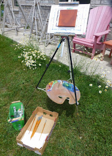
After a swim I thought I would paint some flowers and illustrate to the granddaughters how to paint en plein air. A simple approach to equipment and material does not get in the way of inspiration. I had not painted for a few weeks and I did not want to get rusty. 

Northerly streets of turbulent stratocumulus controlled the lighting on these daisies. Bright and burning sunlight alternated with pleasant shade and clouds. The clouds streets edged further apart as the midday temperatures climbed. 

It was hotter in Tuktoyaktuk, Northwest Territories. Tuktoyaktuk is set on Kugmallit Bay, near the Mackenzie River Delta, and is located on the Arctic tree line. Weather that gets repeated becomes climate. Polar regions are warming up at a rate four times that of the rest of the Globe. 

For this and much more art, click on Pixels. Thank you. 


#2682 "Morning Anvils and Congestus"

#2682 "Morning Anvils and Congestus"
8x10 inches oil
The morning sky was very convective. This is the third in the sunrise series for Thursday June 16th, 2022 that include #2680 "Singleton Morning Cumulonimbus", #2681 "Castellanus in the Wake of the CB" and #2682 "Morning Anvils and Congestus". 

Water Vapour Imagery at the time of the painting 
Water vapour imagery revealed that four or perhaps five lines of concentrated instability were spaced between the leading edge which had just passed Singleton and the cold front which would arrive later in the afternoon. The structure of those convective bands remain to be fully understood. Nocturnal low level jets figure prominently along with Langmuir streaks in helping to explain these bands. I used these tools in a forecast sense but lacked the observational data that would decisively determine the science behind these structures. 

Synoptic Situation Weather Map 
This view was directed toward the northern portion of the second line as it crossed the Singleton forest. The underside of an anvil from a thunderstorm along that line filled the sky. Secondary towers were developing from whatever surface convergence boundaries were created by the first thunderstorm. The air mass was very unstable with lots of convective energy. Shreds of SCUD (Scattered Cumulus Under Deck) cloud were racing around in the low levels on the atmosphere. These pieces over the Singleton forest were headed northward. Some trees within that forest would be knocked down later in the day. It is a small canvas but it contains a lot of meteorology to be discovered. 

The damage June 16th, 2022 was not as severe as the derecho of May 21, 2022 but still extensive. Both affected the Quebec City-Windsor Corridor, Canada's most densely populated region. 

For this and much more art, click on Pixels. Thank you. 


Saturday, September 10, 2022

#2681 "Castellanus in the Wake of the CB"

#2681 "Castellanus in the Wake of the CB"
8x10 canvas oils

This is the view corresponding to #2680 "Singleton Morning Cumulonimbus" but looking out over the lake to the west at the weather that was approaching. There was a band of clear skies overhead but further to the west, skies were overcast. 

Water Vapour View at the time of the painting
The clouds on the leading edge were very convective castellanus. Further in the distance were gravity waves rippling on the warm frontal surface. I would guess that those gravity waves would fall into the "swell" category as the clouds were drifting fairly slowly toward the south with the winds in the atmospheric frame of reference. There were stronger westerly winds much further to the west that would be generating this ocean like swells that rippled the warm frontal surface - like a blanket on a clothes line shaken by a strong wind. 

The wedge of cool air was very shallow and identified mainly by moisture content. That frontal surface was eroded by noon and the temperatures and southerly winds both increased. 

This is the first in the sunrise series for Thursday June 16th, 2022 that include #2680 "Singleton Morning Cumulonimbus", #2681 "Castellanus in the Wake of the CB" and #2682 "Morning Anvils and Congestus". My painting #2663 "Singleton Calm After the Storm" deals with the image of the Derecho of May 21st, 2022. 

For this and much more art, click on Pixels. Thank you. 


Thursday, September 8, 2022

#2680 "Singleton Morning Cumulonimbus"

#2680 "Singleton Morning Cumulonimbus"
10x8 inches oil

The sunrise heavy thunderstorm that delivered 14 mm of rain was on its way out to the east but it was going to be a very unstable day. The cold front and frontal wave would produce afternoon supercellular thunderstorms and damaging winds. We certainly lost some trees in the forest. We had a very large limb down on the lawn that I needed the tractor to move. The one stem of our shagbark hickory flexed and snapped the restraining cable that was designed to save the old and precious tree. Nature arrives all year long to feast on the nuts. 

This is the view corresponding to #2681 "Castellanus in the Wake of the CB"" but looking toward the east at the sunrise thunderstorm that was exiting eastern Ontario. 

Environment Canada Product
My Brother had noticed a very scary graphic published by an on-line weather provider the day before. My answer to his questions was "only Environment Canada can issue warnings. The graphic looked terrifying and that was the provider trying be sensational and gather an audience. It was a summer cold frontal situation and yes, there was bound to be strong convection. The biggest threat was at the frontal wave and if the system occluded like this numerical guidance suggested, the threat was west to east along a line through Ottawa... "  I have not included the scary on-line graphic. The Environment Canada Thunderstorm Outlook issued on the morning of June 16th, 2022 is to the left. 

Sample Numerical Weather Guidance
Water Vapour Image from the time of my painting
This is the first in the sunrise series for Thursday June 16th, 2022 that include #2680 "Singleton Morning Cumulonimbus", #2681 "Castellanus in the Wake of the CB" and #2682 "Morning Anvils and Congestus". My painting #2663 "Singleton Calm After the Storm" deals with the image of the Derecho of May 21st, 2022. 

The damage from June 16th, 2022 was not as severe as the derecho of May 21, 2022 but still extensive. Both affected the Quebec City-Windsor Corridor, Canada's most densely populated region. The May Derecho of 2022 ranked as the sixth costliest in Canada in terms of insurance claims. 

From my days working with CANWARN and Environment Canada, we knew that it was only a matter of time before these and other storms would affect the area. An strong La Nina was still dominating the central Pacific and the impacts of that phenomenon reach out to affect Canada and indeed the Globe. Sahara dust storms and the Atlantic hurricane season are also strongly linked to La Nina. My performance measurement work from around 2000 revealed these correlations but it was outside my time and responsibility to pursue the science behind these linkages. My painting #2663 "Singleton Calm After the Storm" deals with the image of the Derecho of 2022. 

For this and much more art, click on Pixels. Thank you. 

Sunday, September 4, 2022

#2679 "Nuphar Pumila"

#2679 "Nuphar Pumila"
10x12 inches oil

This is the flower friend of #2678 "Reflections of a Yellow Water Lily". I picked the Latin name for the water lily so that the title of this painting would be certain to be unique. I had to look this up as Latin is all Greek to me. 

I was out for a paddle on Monday June 6th, 2022. A friend took my picture as I paddled. It was the 78th Anniversary of D-Day. I was remembering my Father who was there in France. Rain was on the way. 


All kinds of aquatic creatures love these flowers and eat them whole, including beavers and muskrats. This particular flower was one of the few remaining blooms. The other stems had already been nipped off. These flowers were in the southwestern bay of Singleton Lake. 

Friday, September 2, 2022

#2678 "Reflections of a Yellow Water Lily"

#2678 "Reflections of a Yellow Water Lily"
12x10 inches oils

I was out for a paddle on Monday June 6th, 2022. I tend to paint flowers in the early summer and these yellow water lilies certainly qualify. This is the way the yellow lily looked at 9 am on that day, the 78th Anniversary of D-Day. I was remembering my Father who was there. 

All kinds of aquatic creatures love these flowers and eat them whole, including beavers and muskrats. This was one of the few remaining blooms. The other stems had already been neatly nipped off. 

I wanted to capture how some of the pads were submerged, floating half way in between - without being photographic. The reflections of the flower in the water surface were also interesting. 

I have painted lily pads in #1375 "Singleton Lily Pads", #1378 "Yellow Waterlily", #1379 "Lily Swirls", #1457 "Lily Pads and Lilacs", #1745 "Yellow Lily", #1802 "One Yellow Lily", #1887 "Swamp Lilies", #2175 "Jim Day Lily Pads", #2385 "Bullhead Lily" and #2679 "Nuphar Pumila"

For this and much more art, click on Pixels. Thank you. 


#2908 "December Sunrise Cold Fropa"

#2908 "December Sunrise Cold Fropa" 11x14 inches 8 am on Tuesday, December 17th, 2024  from very near N44.522754 W76.105050 The De...